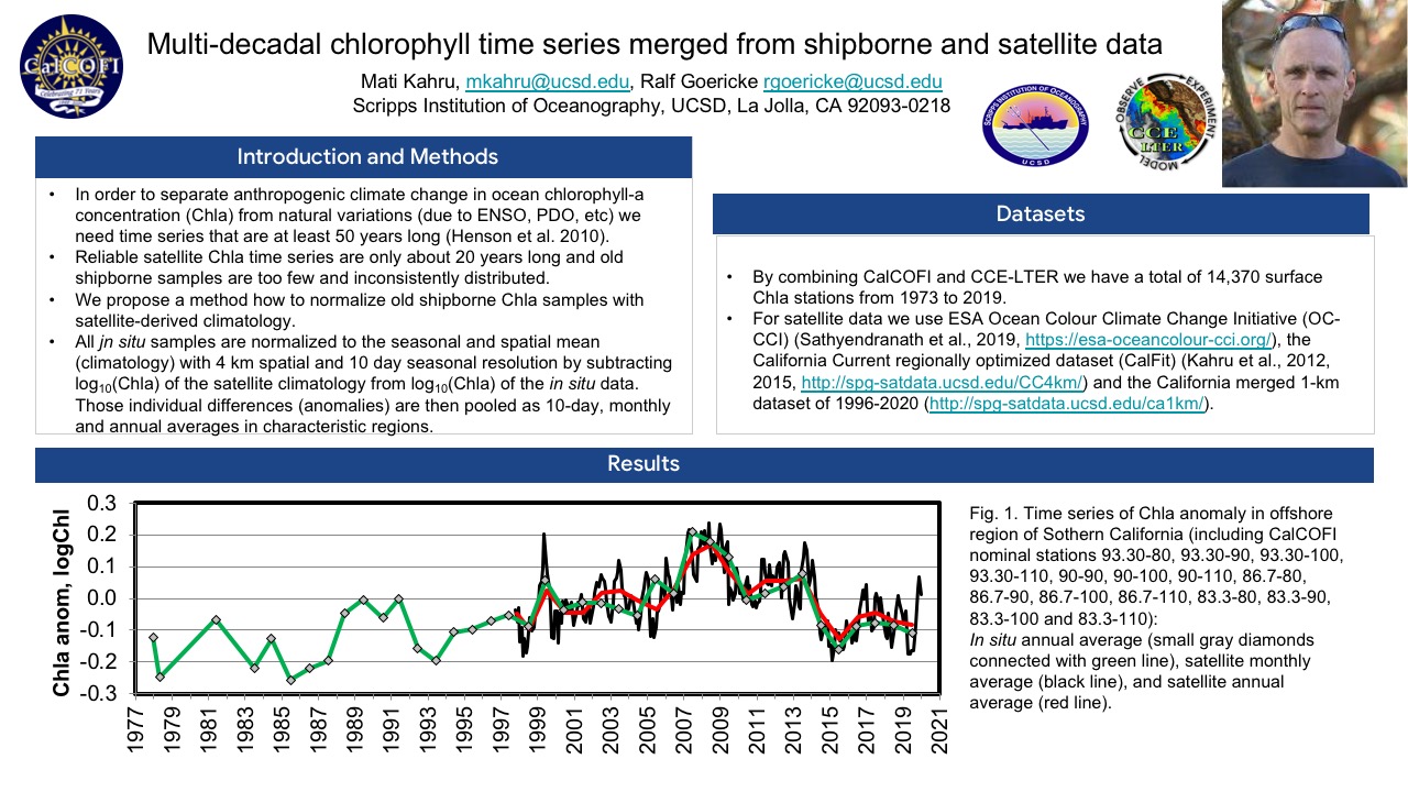
Most historic shipborne data samples collected decades ago are difficult to interpret in consistent time series as they are sparse in both space and time and have unknown contributions from seasonal and spatial variability components. Satellite data, on the other hand, have high and consistent resolution in both space and time but their time series are typically too short to resolve climate variability. We normalize sparse historic shipborne data of chlorophyll-a concentration (Chla) off California to a highly resolved satellite-derived climatology. By using a 10-day climatology of satellite-derived surface Chla accumulated over the last 2 decades we can normalize historic shipborne data relative to each sample’s location on a 4 km grid and a 10-day timing window in the annual cycle. The normalized historic shipborne data are then merged from both in situ and satellite data, creating a consistent and extended time series of Chla for the California Current Ecosystem for 1977-2020.
The NOAA-CalCOFI Ocean Genomics (NCOG) program has been collecting DNA and RNA in a standardized fashion from every CalCOFI cruise since 2014. DNA-based amplicon sequencing or metabarcoding enables molecular-based assessments of the distribution and diversity of particular microbes and functional groups with high taxonomic resolution. Whole community sequencing of RNA or metatranscriptomics allows for further examination of the functional activity of these organisms. With currently 1000 DNA samples and over 400 RNA samples, comprehensive examination of the microbial community with environmental context in the Southern California Current Ecosystem is possible. Here we highlight two studies using NCOG data to provide insights into the ocean microbiomes in the region. James et al. (in prep) explores cross-shore gradients in community structure and diversity showing that nitracline depth and chlorophyll a are strong predictors. Zeigler Allen et al. (in prep) links patterns in primary productivity to taxon-specific measurements of phytoplankton activity. Continued sample collection on future CalCOFI cruises, additional DNA sequencing of other amplicons such as 12S for fish, and deeper eukaryotic RNA sequencing will enable further ecological discovery and highlight eDNA as a tool for ecosystem monitoring.
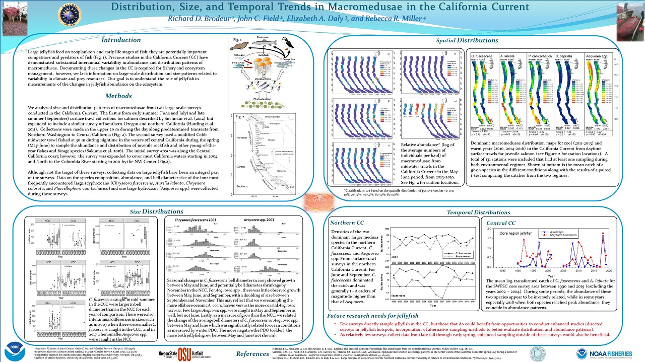
Large jellyfish feed on zooplankton and early life stages of fish and they are potentially important competitors and predators of fish. Previous studies in the California Current (CC) have demonstrated substantial interannual variability in abundance and distribution patterns of macromedusae. Documenting these changes in the CC is required for fishery and ecosystem management, however, we lack information on large-scale distribution and size patterns related to variability in climate and prey resources. Detailed quantitative data were collected on macromedusae from two large-scale surveys conducted in the California Current. Data on the species composition, abundance, and bell diameter size of the four most frequently encountered large scyphozoans (Chrysaora fuscescens, Aurelia labiata, Chrysaora colorata, and Phacellophora camtschatica) and one large hydrozoan (Aequorea spp.) were analyzed. Our goal is to understand the role of jellyfish in measurements of the changes in jellyfish abundance on the ecosystem.
In a program developed for community scientists and college students, methods have been developed to observe microplastics in seawater samples collected in the Monterey Bay. Basic bright-field microscopes were adapted for polarization and fluorescence detection which helped to distinguish plastic fragments and fibers from natural material. These modifications cost less than $100 making the approach accessible to many organizations. The procedures can be used to bring microplastics to the attention of the public at outreach events, as well as providing a topical practical exercise for students from schools and universities.
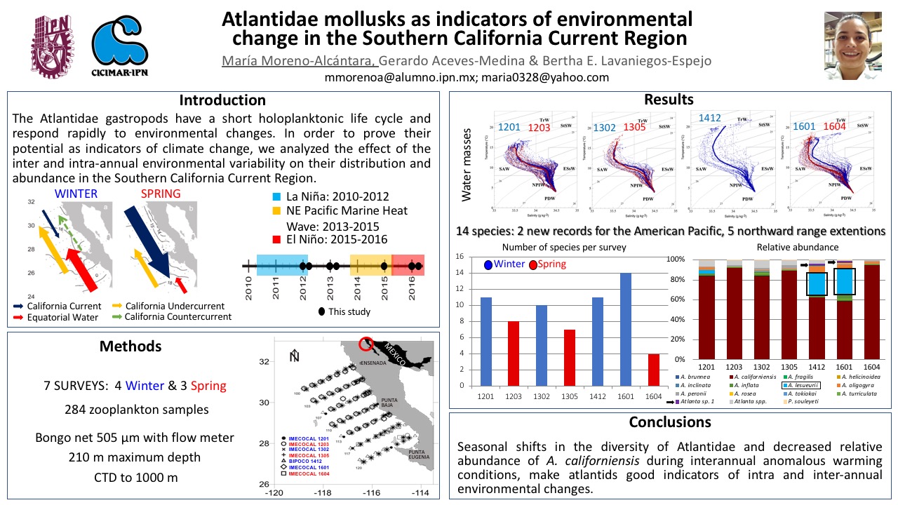
The holoplanktonic gastropods of the family Atlantidae (Pterotracheoidea) have a short life cycle, and even though they respond rapidly to environmental changes, it is unknown how their distribution and abundance vary regarding the intra and inter-annual changes in the environmental conditions. In the California Current System (CCS) the most intense intra-annual changes in the environmental conditions and in the planktonic species composition happen between winter and spring. Other important changes in the environment happen in the inter-annual scale; in this study mainly related to the northeast Pacific marine heat wave 2013-2015 and El Niño 2015-2016. We determined the intra and inter-annual variation of the distribution and abundance of Atlantidae species in the Pacific coast off Baja California between 2012-2016. Four oceanographic cruises were carried out in winter and three in spring with 284 zooplankton samples analyzed. Overall, 14 species were found where Atlanta californiensis was the most abundant, mainly in spring. During winter 2014 and 2016, warm anomalies occurred and the relative abundance of A. californiensis decreased, while A. lesueurii increased. The differences in the community structure shows that atlantids are good indicators of intra and inter-annual environmental changes in southern CCS.
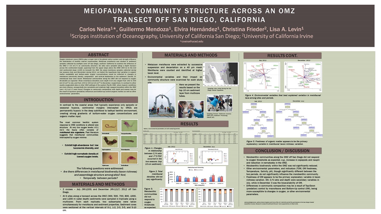
Oxygen minimum zones (OMZs) play a major role in the global carbon system and strongly influence the distribution of benthic marine communities. Metazoan meiofauna was studied in sediment samples collected by multiple corer off San Diego, southern California to examine the influence of the Oxygen Minimum Zone (OMZ; <0.5 ml L-1) on community structure. Six sites were sampled along a depth transect across the continental margin, spanning from the upper slope above the OMZ (300 m) to the mid continental slope (1200 m) beneath the OMZ. By using meiofauna samples collected during two seasons (July and December) during 2012, we tested the hypothesis that variation in organic matter availability and bottom-water oxygen concentrations would be reflected in changes in meiofaunal community density, composition and vertical distribution in the sediment. Overall, 21 meiofaunal taxa were found. Meiofaunal communities along the OMZ did not respond to oxygen thresholds as expected. Mean meiofauna densities (core depth 0-10 cm) ranged from 202 to 456 ind. 10 cm-2 in July, and from 235 and 530 ind. 10 cm-2 in December, respectively. In contrast to other nearby oxygenated sites or other OMZ settings of the eastern Pacific OMZ, where the hypoxic conditions are more intense, unexpectedly low nematode and relatively high copepod densities within the OMZ core (~0.2 ml L-1), were found. Changes in community composition with depth and season may be the result of top-down (predation) influences and bottom-up control (organic matter) as well as other environmental parameters.
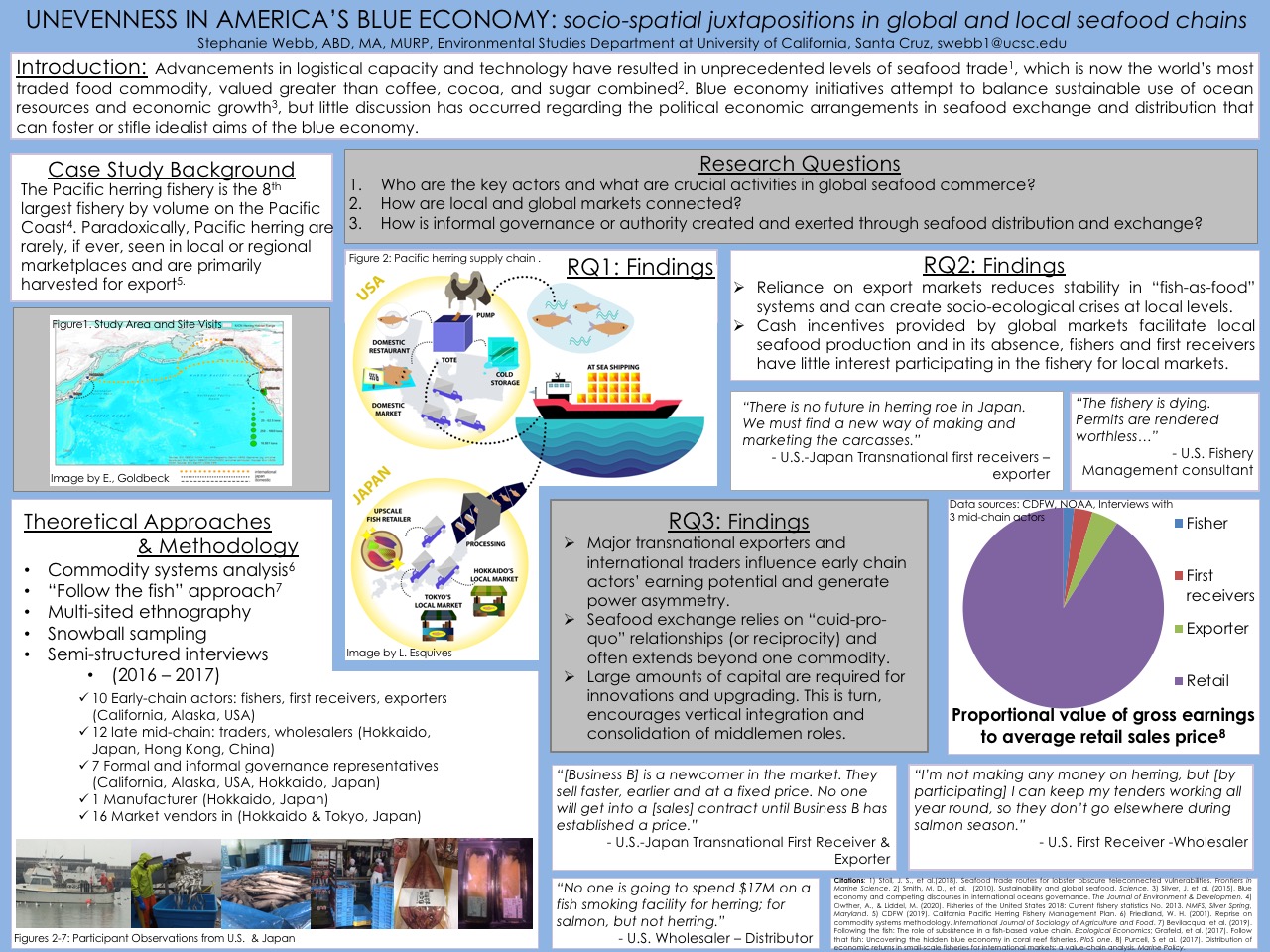
I examine the actors and configuration of the global Pacific herring commodity chain using multi-sited ethnography and semi-structured interviews to explain the power relations in and connections facilitating multilevel seafood commerce. I conducted interviews with commercial fishers and first receivers in San Francisco, manufactures and merchant booths in Hokkaido and Tokyo, Japan as well as transnational seafood dealers at the Seafood Expo Asia in Hong Kong. I demonstrate that major transnational exporters and international traders generate power asymmetry through “quid-pro-quo” relationships (or reciprocity) and influence early chain actors’ earning potential. Export markets also create cash incentives based on high volume, low value paradigms that often facilitate local seafood production, and in its absence fishers and first receivers have little interest participating in the fishery for local markets. Reliance on export markets ultimately undermines America’s blue economy and reduces stability in “fish-as-food” systems.
The Eastern Tropical North Pacific (ETNP) is characterized by high primary production and suboxic mid-water conditions in the water column. These have been used to explain temporal variability in sedimentary stable nitrogen isotopic composition (d15Nsed) within the oxygen minimum zone (OMZ: ~200 to 800 m depth) and to determine changes in denitrification over different time scales. We present new d15N data from surface sediments (d15Nsed), which are compared with isotopic compositions of nitrate (d15N-NO3-) and d15N of organic matter in sinking particulates to investigate the relative contributions of water-column denitrification and surface nitrate assimilation to the sedimentary nitrogen isotope record. The d15Nsed values showed gradients in 15N enrichment, both across the margin within the ETNP and with latitude when considering the margin of California. The d15Nsed is controlled by nitrogen loss processes within the OMZ and the degree of utilization of available nitrate in the euphotic zone.
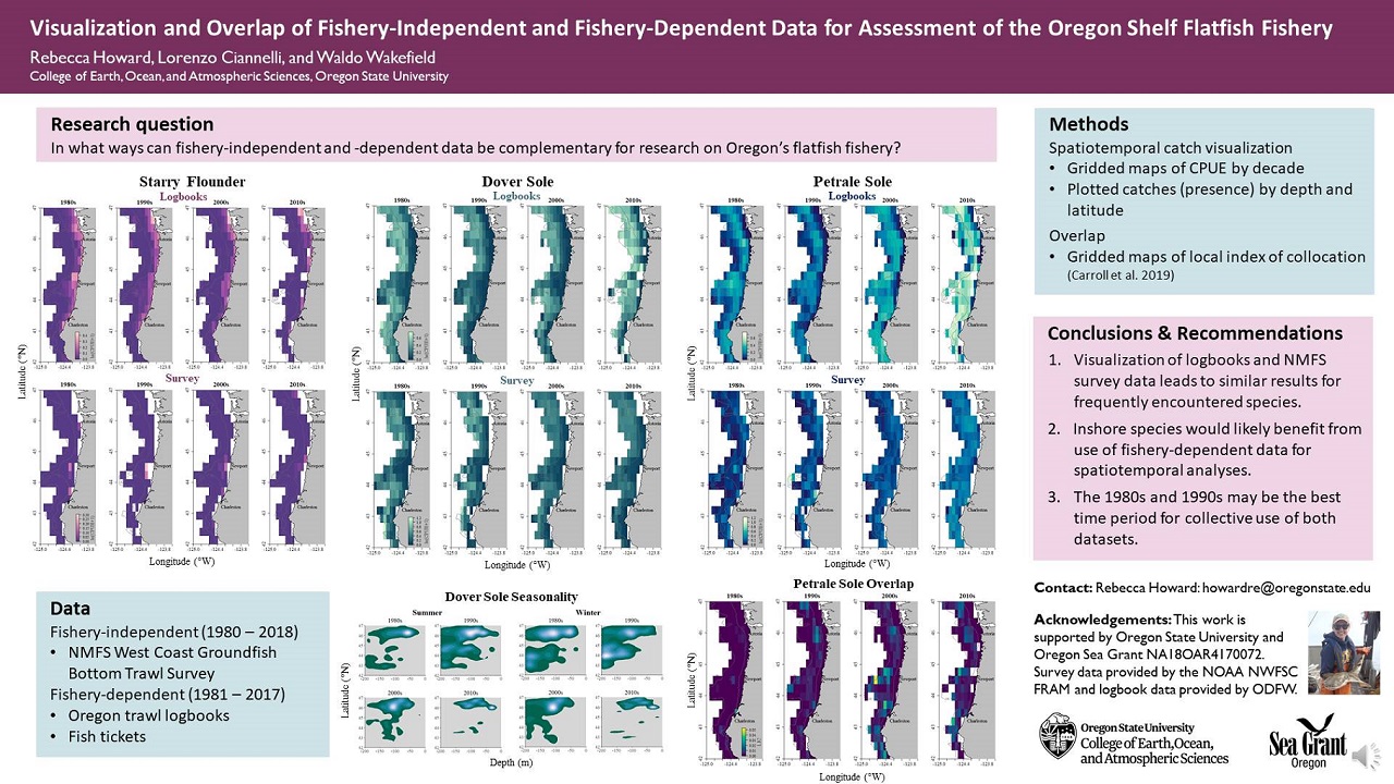
The commercial non-whiting groundfish fishing industry and corresponding research activity have a long concurrent history on the Oregon continental shelf. Limitations in temporal and spatial extent of scientific data has led to a gap in understanding of population dynamics within the shelf fishery. Although National Marine Fisheries Service (NMFS) surveys have been conducted across most of the adult groundfish fishery’s depth range, this fishery-independent data has not been collected for every year or season and there is an absence of data inshore of 55 meters water depth. Logbooks, self-reported fishery-dependent data collected by fishing vessels, cover shallow waters and a broader time range than survey data. To investigate the potential utility of combining both fishery-independent and -dependent data for future analyses, we analyzed changes in catch over space and time, as well as gaps in fishery and scientific survey data, for six flatfishes. We found that between 1980 and 1998, the NMFS surveys have the most information gaps and had the highest potential to benefit from complementary use of fishery-dependent data for spatial and temporal analyses. Commonly caught species, like Dover sole and petrale sole, had better spatial sampling coverage of their populations compared to species that live in shallow water, such as starry flounder and sand sole. Overlap between datasets was variable but often highest near Astoria and Newport, OR. This research illuminates where knowledge gaps lie in both data types and how they complement one another, providing more context for future management of shelf groundfishes.
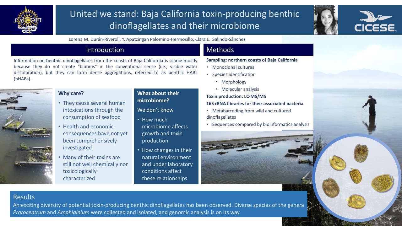
Information on benthic toxin-producing dinoflagellates from Baja California coasts is scarce as is their phycosphere, and how the associated bacteria relate to toxin production in natural and laboratory conditions. Our goal is to identify the species from this area and unravel their microbiome differences in both conditions.
Monitoring programs around the world attempt to capture the impact of wastewater plumes through observational studies but can often miss the plume because of its ephemeral nature and varying ocean conditions. 3D numerical ocean modeling with particle tracking can be used to determine probability based visitation frequency of the plume during different seasons and residence times. Observational programs and wastewater managers can use this modeling tool to improve plume monitoring by updating monitoring locations to better capture plume impact in the ocean.
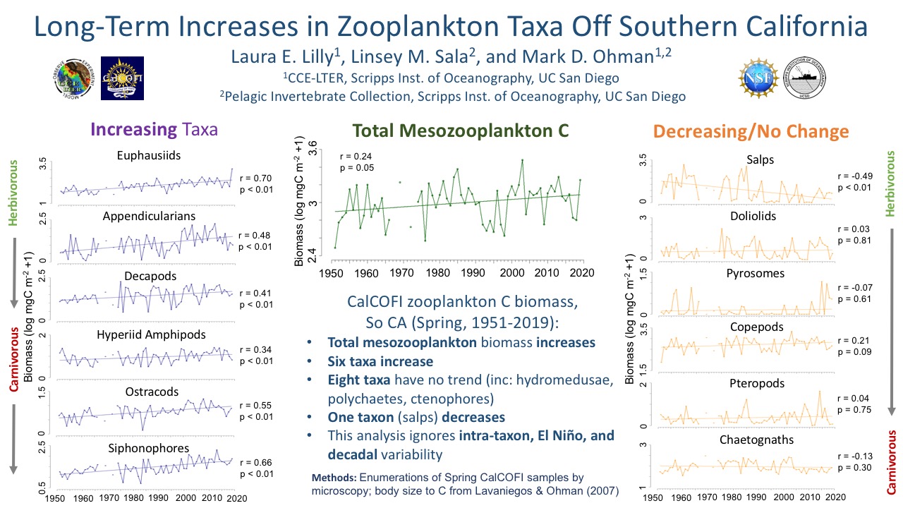
We present here evidence for significant long-term increases in carbon biomass of six zooplankton taxa (euphausiids, appendicularians, decapods, hyperiid amphipods, ostracods, siphonophores) using interannual spring CalCOFI samples from the Southern California region, 1951-2019. We also present a long-term increase in total mesozooplankton carbon biomass. We contrast these increases with nine taxa that show decreases (salps) or no long-term changes (eight other taxa).
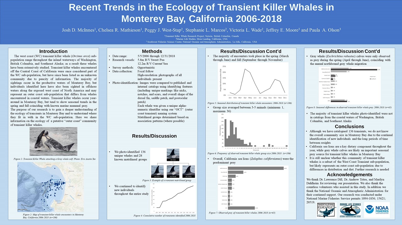
The west coast (WC) transient killer whale (Orcinus orca) sub-population range throughout the inland waterways of Washington, British Columbia, and Southeast Alaska; as a result these whales have been extensively studied. Transient killer whales encountered off the Central Coast of California were once considered part of the WC sub-population, but have since been listed as an unknown community due to paucity of information. The majority of sightings occur in the productive waters of Monterey Bay, but individuals identified here have also been sighted in offshore waters along the exposed west coast of North America and may represent an outer coast sub-population that differs from whales encountered in coastal waters. Transient killer whales occur year-around in Monterey Bay, but tend to show seasonal trends in the spring and fall coinciding with known marine mammal prey. The purpose of our research is to gain a deeper understanding of the ecology of transients in Monterey Bay and to understand where they fit in with in the WC sub-population. Here we share information on the ecology of a putative “outer coast” community of transient killer whales.
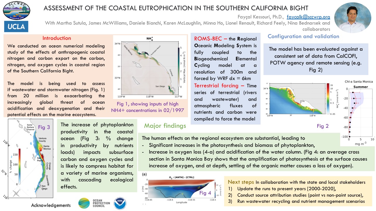
We conducted an ocean numerical modeling study of the effects of anthropogenic coastal nitrogen and carbon export on the carbon, nitrogen, and oxygen cycles in coastal region of the Southern California Bight. The model is being used to assess if wastewater and stormwater nitrogen from 20 million is exacerbating the increasingly global threat of ocean acidification and deoxygenation and their potential effects on the marine ecosystems.
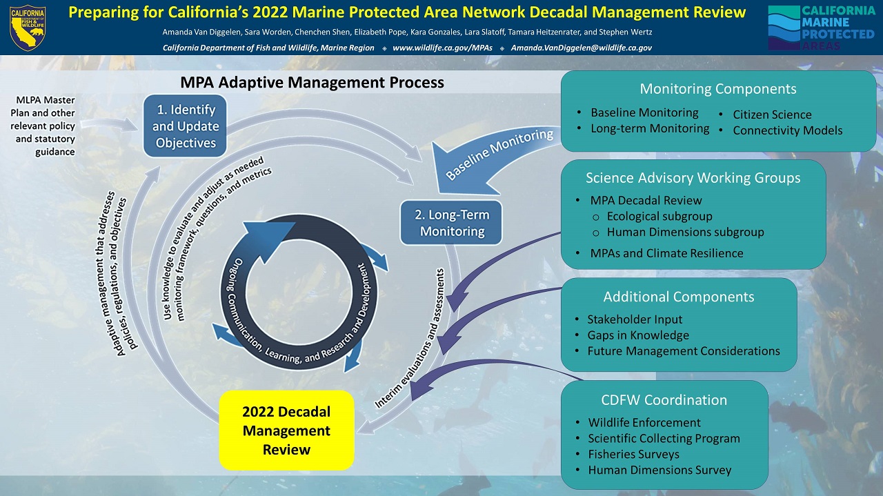
In 2012, California finalized implementation of the largest ecologically connected network of marine protected areas (MPAs) in the world. Designed using a scientifically guided, stakeholder-driven approach, the MPA Network consists of 124 individual MPAs that encompass approximately 16% of California’s jurisdictional waters, with 9% in no-take MPAs. In December 2022, California will achieve a major milestone in marine spatial planning and conservation with the first formal management review of the statewide MPA Network. As California approaches the 10-year anniversary, the California Department of Fish and Wildlife (CDFW) is preparing a decadal management review on the MPA Management Program and evaluating progress of the MPA Network towards meeting the goals of the Marine Life Protection Act. This poster outlines the primary components that will inform the first decadal management review, including scientific working groups, monitoring data, internal CDFW coordination, and additional considerations. As the State moves towards this important milestone, CDFW and partners will share informational updates and what to expect with this decadal management review.
Nitrate upwelling in the CCE is largely transported along the California Undercurrent (CUC), which makes its way north from the tropics at depths between 200 and 500 m. This water is characterized by relatively low nitrate concentrations and elevated N and O isotopes of nitrate due to denitrification in the oxygen deficient zones of the eastern tropical North Pacific. The influence of this water is evident in the elevated average isotopic signature of deepwater nitrate in the CalCOFI region, although it is not fully understood however how this influence varies over time. Recent work (Bograd et al. 2015, 2019) has used other CalCOFI measurements such as temperature, salinity, and nutrient concentrations to estimate the influence of different water masses. However, nitrate isotopes are a more sensitive measure of the CUC. Here we use nitrate isotopes samples collected from CalCOFI lines 80 and 93 from 2010-2016 to address the ongoing debate about the influence of various source waters in the CCE.
Prior studies have described a nutrient gradient caused between stronger coastal upwelling and weaker, offshore wind-stress upwelling within the California Current System (CCS). The nature of eastern boundary currents (slower, shallower and wider compared to western boundary currents) force wind patterns that drive greater magnitudes of upwelled nutrients onshore but greater volumes of nutrients over large regions offshore. This nutrients gradient, in turn, causes a gradient between ecosystem regimes within phytoplankton community structure. Using mooring, shipboard (CalCOFI dataset), and satellite remote sensing observations (Aqua-MODIS) data, our study aims to answer the following questions: how does phytoplankton biodiversity vary perpendicular to shore, across a nutrient gradient, from a coastal upwelling to a wind-stress curl upwelling region? And how well can remotely sensed images portray this phytoplankton size class (PSC) distribution? A number of different PSC algorithms will be used to process Level 1B Aqua-MODIS data to be compared with in situ (CalCOFI) datasets. We anticipate our findings will show matchups between in situ data and remotely sensed data supporting a PSC gradient between onshore and offshore upwelling systems. Given that different size classes support different trophic systems, our results have the potential to hint at shifts within higher trophic levels.
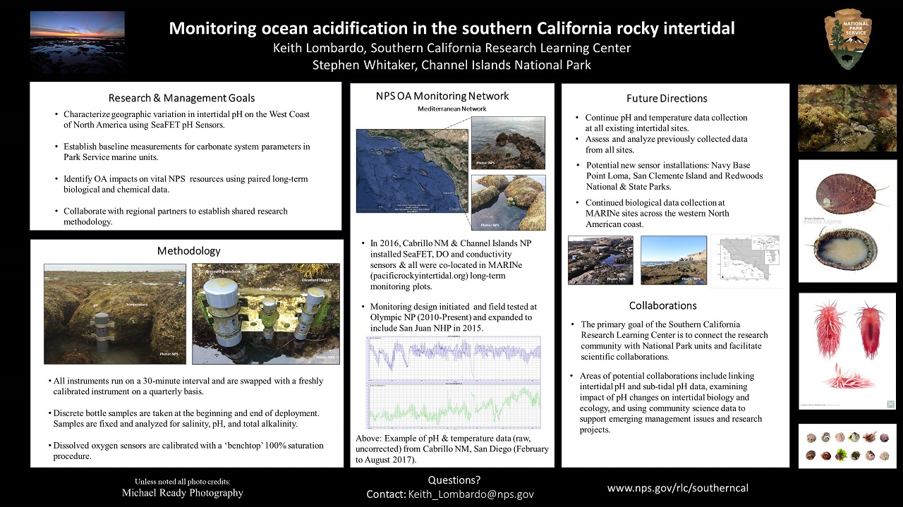
In 2010, the National Park Service launched an ocean acidification (OA) monitoring program to enhance our understanding of the changes documented in our long-term rocky intertidal datasets. The OA program, which originated in Olympic National Park, now includes 4 sites along the west coast of the United States and additional sites are being assessed and planned. As we surface from our implementation period, the Southern California Research Learning Center is now actively engaging and collaborating with the research community to address emerging natural resource issues in our marine-based National Park Service units.
Regional monitoring programs are a powerful tool for water quality scientists and coastal managers alike. Regional monitoring provides scientists the opportunity to study fundamental ecosystem mechanisms and processes over large biogeographic spatial scales, scales that are simply too difficult and costly to accomplish as a single investigator and are often too sparsely monitored for national programs. The Southern California Bight Regional Marine Monitoring Program (the Bight Program), which began in 1994 and run every five years since, is a collaborative monitoring program consisting of nearly 100 regulated, regulatory, non-governmental and academic institutions. The Bight Program has affected management actions in the region by focusing management effort on habitats most impacted by poor sediment and water quality, highlighting improvements from previous management actions, and characterizing emerging threats to the coastal zone, such as ocean acidification. Looking forward, the Bight Program is working towards characterizing shifting baselines in the Bight. Climate change is expected to have significant impacts on coastal ecosystems, altering freshwater inputs, and warming, deoxygenating, and acidifying waters. These changes will have significant impacts on the structure and function of aquatic ecosystems, as well as the fate and transport of contaminants. In an era of shifting baselines, regional monitoring can provide managers robust data on shifting reference condition(s) as a benchmark for assessing magnitude of local anthropogenic alteration, evaluating cumulative impacts from multiple pollutant sources, and ranking changes in habitat quality and biological impacts among different types of human activities that are attributable to both global and local changes. Towards this end, the Bight Program is working to implement new indicators, metrics, and assessment frameworks to evaluate ecosystem impacts due to climate change. However, Bight monitoring is only as good as its ability to compare to other monitoring programs, such as CALCOFI. Bight Program participants are looking to unify best practices to compare across monitoring programs along the US West Coast and look forward to working with other programs to establish these protocols to develop the managerially relevant monitoring datasets of the future.
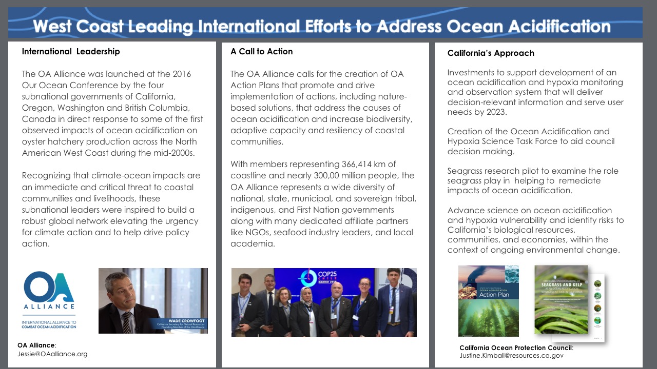
Co-created by the State of California, the OA Alliance calls for the creation of OA Action Plans that promote and drive implementation of actions, including nature-based solutions, that address the causes of ocean acidification and increase biodiversity, adaptive capacity and resiliency of coastal communities.
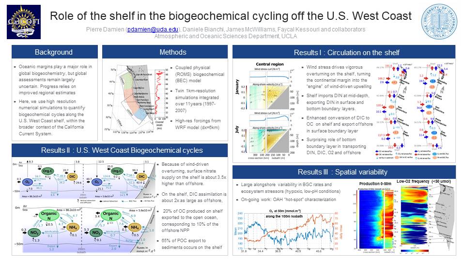
We use high resolution numerical simulations with a physical-biogeochemical model of the US West coast to investigate: (1) the dynamics of upwelling on the continental shelf; (2) the dynamics of C, N, O cycles on the shelf; (3) the role of the shelf for the US West Coast biogeochemical balances of C, N, O; (4) variability and hot-spots of hypoxia and acidification on the shelf
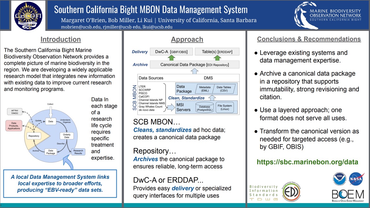
Observational time series and research projects often justify their activities by suggesting that data may be used by agencies for decision making or to provide indicators of ecosystem health. The Southern California Bight Marine Biodiversity Observation Network (SBC MBON) is developing a scalable network to integrate data relevant to the status of marine biodiversity over large temporal and spatial scales, and to act as a ‘broker’ for data to be used for regional decision making SBC MBON employs a variety of data sources: ad hoc research data, opportunistic sightings, routine surveys and monitoring programs, that cover essentially all taxonomic or marine functional groups. The data types and their properties are heterogeneous, and in addition to traditional manual surveys, include genomics data, aerial counts and remote sensing. Here, we summarize features of the SCB MBON data management system, which addresses the challenges inherent when handling diverse, heterogeneous data formats and sources, including the need to support initiatives such as the GEO BON Essential Biodiversity Variables (EBVs). Our approach demonstrates the level of attention in specific areas of data management that are necessary if ad hoc research data are to be reused or integrated with larger observatory-oriented missions. The DMS leverages existing software, ensures archive of an immutable copy, and allows for reformatting of data for a variety of uses.
This project was initiated in 2012 to analyze fish spawning activities surrounding the Scripps Pier and to establish a baseline of egg abundance and species diversity to compare to future years. This information is useful for fisheries, conservation efforts, and general research purposes. We looked at the spawning activity of fish off of Scripps Pier to better understand their patterns and any potential causes for deviations from these patterns. In 2019 the project was expanded to incorporate sampling from 5 additional sites along the California Coast: Newport Beach, Santa Monica, Santa Barbara, San Luis Obispo, and Santa Cruz. Comparing data from all 6 sites can be used to address questions about spawning patterns and population structure along a thermal and latitudinal gradient. In the future, this data will be useful in hypothesizing how a changing ocean environment affects specific populations and whole ecosystems.
Under changing climate conditions, marine organisms will need to cope with or adapt to increasing temperatures to persist. Parental effects, where offspring responses to environmental change are influenced by parental environments through non-genetic changes and maternal provisioning, may influence the ability of populations to cope with thermal stress. This study evaluated whether thermal environments across a natural gradient (tide height) impacted the temperature tolerance of larvae of the mussel, Mytilus californianus. Adult mussels were collected from the rocky intertidal of Newport Beach, CA, USA. LT50 (temperature lethal to 50% of individuals) was quantified for field-collected adults and their 3-day old veliger larvae raised in the laboratory. We used a generalized linear mixed model approach to examine which factors predicted larval mortality. The best-fit model indicated that LT50 assay temperature, adult (parent) LT50, and parental environment (collection tide height) all significantly contributed to level of larval mortality. Overall, survival was lowest for larvae with parents who were collected from the warmest environment (high tide height). Egg diameter varied by tide height, with the smallest eggs occurring at high tide height. Adult gonadosomatic index, a measure of reproductive condition, varied significantly by tide height with lowest condition in high tide height mussels. These results suggest parental effects are maladaptive for thermal tolerance and indicate negative effects of stress. Stressed mussels may invest less in reproduction leading to lower larval tolerances. Thus, maladaptive parental effects could leave larvae more vulnerable to thermal stress and impact the survival of the mussel under climate change.
Initial results are presented from real-time moorings installed in partnership with Uwe Send’s lab at Scripps Oceanography. One main goal of this project is to better understand the dynamics of treated wastewater effluent from the City’s two ocean outfalls, and how water quality and conditions change throughout the year.
In 1951, Hopkins Marine Station of Stanford University (HMS) became an official component in the developing California Cooperative Oceanic Fisheries Investigations (CalCOFI) program to collect oceanographic data in Monterey Bay. Hopkins staff conducted weekly sampling (more or less) continuously from March 1951 through June 1974. The aim of the program was to conduct joint fisheries-oceanographic cruises that would help researchers understand what contributed to the crash of the sardine fishery in the California Current. The HMS CalCOFI dataset is an extremely important contribution to early oceanographic research in the Northeast Pacific Ocean, and extends our observations in this area decades into the past. After the end of the program in 1974, the logbooks, raw data and formal reports sat quietly in the library at HMS. In 2017, a majority of these materials were digitized and made available as images and PDFs in the Stanford Digital Repository. Our efforts have now shifted toward extracting the most important observational data from the scans so they can be shared as actionable datasets. This poster summarizes the dataset and our work to make these critical data available for researchers.
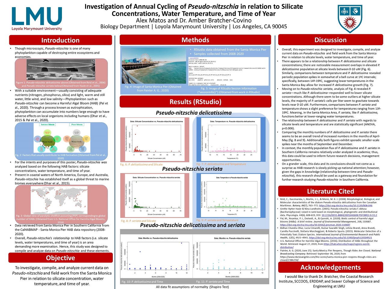
The contents of this poster investigates, compiles, and analyzes current data on Pseudo-nitzschia and field work from the Santa Monica Pier in relation to silicate concentration, water temperature, and time of year. We made comparisons between Pseudo-nitzschia delicatissima and P. seriata regarding the aforementioned measurements. Considering the shortage of data in this area, this research could be used to inform research decisions and future management opportunities.
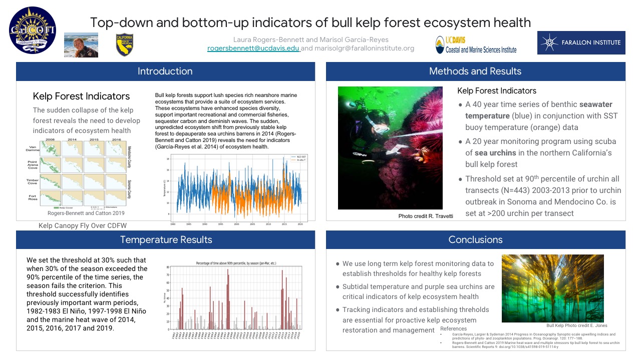
There has been an unprecedented and unanticipated collapse of the nearshore kelp forest in northern California in conjunction with the marine heat wave. The bull kelp, Nereocystis luetkeana, forest once supported a rich biodiverse ecosystem providing ecosystem services such as commercial and recreational fisheries along with carbon sequestration and wave buffering. The previously resilient kelp forest shifted suddenly to sea urchin barrens following the loss of sea star predators and the onset of the marine heat wave in 2014 (Rogers-Bennett and Catton 2019). We examine both top-down (sea urchin herbivory) and bottom-up (sea water temperature and related nutrients) controls of kelp in the region. Using long-term temperature records and a 20 year subtidal monitoring program we establish indicators for healthy bull kelp forests in northern California. We find that benthic temperature data at 10m is cooler than the offshore sea surface, temperature data recorded by NOAA buoys. We use 40 years of temperature data from 1981 to 2020 and bin the temperature data by season to quantify the 90th percentiles of each season. We establish a threshold of 30% such that if a season within a year exceeds the long-term 90th percentile of that season for more than 30% of the time that season is categorized as failing the criterion (exceeding the threshold). This indicator successfully identifies previously important warm periods such as the 1982-1983 El Niño, 1997-1998 El Niño and the major marine heat wave of 2014, 2015, 2016, 2017 as well as the recent warm year 2019. We use purple sea urchin, Strongylocentrotus purpuratus, data from a 20 year subtidal monitoring program in northern California to establish a threshold for sea urchin herbivory (top-down control). We find that 200 purple sea urchins on a 60m2 transect exceeds the 90th percentile of all transects (N=443) quantified from 2003-2013 prior to the massive sea urchin population outbreak. Using both top-down and bottom-up indicators we can provide an early warning system for the health of kelp forest ecosystems which we know are susceptible to sudden catastrophic shifts to sea urchin barrens. Maintaining these data streams to inform the management and restoration of nearshore marine ecosystems will be critical moving forward as climate change is predicted to increase the intensity and frequency of extreme events which can trigger ecosystem collapse.
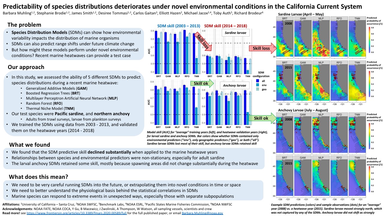
Species distribution models (SDMs) are a commonly used tool, which when combined with earth system models (ESMs), can project changes in organismal occurrence, abundance, and phenology under climate change. An often untested assumption of SDMs is that relationships between organisms and the environment are stationary. To evaluate this assumption, we examined whether patterns of habitat use by larvae of four small pelagic fishes (Pacific sardine, northern anchovy, jack mackerel, chub mackerel) in the California Current remained steady across climate regimes, changes in secondary productivity, and break-points in time series of spawning stock biomass (SSB). Generalized additive models (GAMs) were constructed separately for each period using temperature, salinity, dissolved oxygen (DO), and mesozooplankton volume as predictors of fish occurrence. We assessed non-stationarity based on changes in six metrics: 1) variables included in SDMs; 2) whether a variable exhibited a linear or non-linear form; 3) rank order of deviance explained by variables; 4) response curve shape; 5) degree of responsiveness of fishes to a variable; 6) range of environmental variables associated with maximum larval occurrence. Across all species and time periods, non-stationarity was ubiquitous, affecting at least one of the six indicators. Rank order of environmental variables, response curve shape, and the preferred oceanic conditions were the indicators most subject to change. Non-stationarity was most common among regimes defined by changes in fish SSB. The relationship between fishes and DO was more likely to change across periods, whereas the relationship between fishes and temperature was comparatively stable. We found that the ratio of inter-model variability to mean habitat suitability for sardine increased under two climate change scenarios (SSP1-2.6 and SSP5-8.5), implying that subtle differences in model formulation could have amplified future effects. These results suggest that the widespread non-stationarity in how fishes utilize their environment could hamper our ability to reliably project how species will respond to climatic change.
Ocean uptake of human-induced CO2 emissions is leading to ocean acidification (OA), which negatively affects many marine organisms and ecosystem processes. These effects are recognized for calcifying marine invertebrates and include reduced rates of calcification, growth and survival. By contrast, few studies examine how OA affects reproduction in fishes. There are two main concerns that must be addressed when conducting OA experiments. First, most experimental OA studies have held seawater pH levels constant, which reveal sensitivities and responses of individual species, but may not reflect an organism’s ability to recover from temporary perturbations in realistic coastal zone conditions where pH is highly variable. In the present study, we created lowered pH conditions in laboratory mesocosms while allowing environmental factors (photosynthesis, respiration, temperature) to fluctuate naturally with ambient coastal conditions. Second, OA experiments previously confined to laboratory mesocosms may not incorporate ecologically realistic cues that may alter the perceived effects of OA under natural conditions expected in the field. To understand the effects of lowered seawater pH in combination with natural, fluctuating environmental factors, we deployed collapsible benthic isolation tents (cBITs) in Big Fisherman’s Cove, Santa Catalina Island, to isolate a fixed volume of water surrounding the benthos which tests the feasibility of cBITs maintaining OA conditions. A set of sensors (pH, dissolved oxygen, and temperature) were placed in each chamber to quantify internal seawater chemistry. Our preliminary results indicate that cBITs can be successfully acidified to projected future ocean conditions (e.g. decreased pH by ~0.2 units). These methods have already been improved and provide an innovative solution to examining how human-induced disturbances impact coastal marine ecosystems. Moreover, this methodology increases ecological realism by incorporating additional natural conditions such as predator cues, daily light cycles, and wave motion not replicated in laboratory mesocosms. The next steps in our research are to utilize our improved laboratory mesocosms and cBITs to isolate our study organism, the bluebanded goby (Lythrypnus dalli), to examine the effects of OA on their reproductive output and behavior. Given their small size, site fidelity, and ease of manipulation, L. dalli is an ideal test species and may serve as a model species for numerous other fishes, such as the California Sheephead, with similar life histories, physiological characteristics, and reproductive behavior.
Harmful Algae Blooms pose as a threat to costal marine life, as well as to the health of humans. To get a better understanding of HABs along the coast of Southern California, we looked at the last 12 years of data (recorded once a week) from NCAA’s buoy located at Santa Monica Pier. With this data we were able to compare species as well as variables, such as time, temperature, phosphate, silicate, nitrite, ammonium, and nitrate. After analyzing the data, we were able to identify the ideal environment for HAB growth.
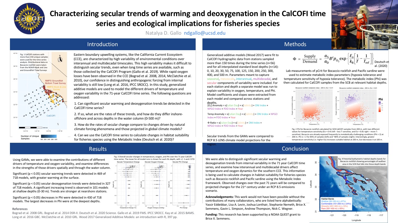
Eastern boundary upwelling systems, like the California Current Ecosystem (CCE), are characterized by high variability of environmental conditions over interannual and multidecadal timescales. This high variability makes it difficult to distinguish secular trends, even when long time series are available, such as those collected by the CalCOFI Program. While rapid oxygen losses have been observed in the CCE, our confidence in distinguishing anthropogenic forcing from internal variability is still low. In this study, generalized additive models (GAMs) are used to model the different drivers of temperature and oxygen variability in the 71-year CalCOFI time series. GAMs were fit to CalCOFI hydrographic data from 56 stations that were sampled more than 150 times during the 71-year time series and for all interpolated standard level depths: 0, 10, 20, 30, 50, 75, 100, 125, 150, 200, 250, 300, 400, and 500 m. Parameters meant to capture seasonal, mesoscale, interannual, multidecadal, and secular components of temperature and oxygen variability were included in the models. Physiological measurements of pCrit for Bocaccio rockfish were used to estimate the metabolic index (Phi) and model changes in Phi. We were able to distinguish significant secular warming and deoxygenation trends from internal variability in the 71 year CalCOFI time series, and examine how interannual and multidecadal drivers affect temperature and oxygen dynamics for the southern CCE. Significant secular warming trends were detected in 469 of 718 models, with greater warming at the surface. Significant secular deoxygenation trends were detected in 327 of 718 models, with stronger declines at nearshore stations. An unexpected trend of increasing oxygen was detected at shallow depths (0-30 m) in 101 models. Significant decreases in Phi were detected in 430 of 718 models, with larger decreases at deeper depths. These results are now being used to estimate potential habitat loss for fisheries species such as Bocaccio rockfish and Pacific sardine using the Metabolic Index framework.